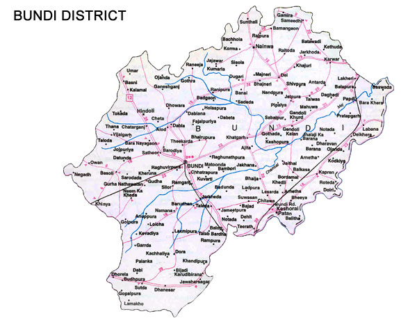
The district is situated in the south-eastern part of Rajasthan. It is bound in the north by Tonk, in the west by Bhilwara and on the south-west by Chittorgarh districts. The river Chambal forms the southern and eastern boundaries separating the Bundi and Kota territories. The southern tehsils of Bundi forms a wedge between Bhilwara and Kota and also touches Chittorgarh district.
Distance from Major Cities
Jaipur-202 kms.
Delhi-483 kms.
Ahmedabad-827 kms.
Mumbai-1,378 kms.
Climate and Rainfall
The district is generally dry except during the monsoon or winter rains.
Maximum temperature is 42.6 degrees celsius
Minimum temperature is 29.7 degrees celsius.
Normal annual rainfall in the district is 76.41 cms.
Administrative Setup
There are two sub-divisions in the district viz., Bundi and Nainwa. These two sub-divisions are further divided into four tehsils.
Human Resources
Indicators of Human Resources
Units
No.
Population
persons
9,61,269
Density of population
persons per sq.kms
173
Literacy
per cent
55.80
Total working population
per cent
34.21
Percentage distribution of work force
Units
No.
Cultivators
per cent
59.26
Agricultural labourers
per cent
9.73
Household industry
per cent
2.59
Other workers
per cent
28.42
Major Crops and Their Production
Sr.
Production 2004-05
Tonnes
1
Wheat
266007
2
Rapeseed & Mustard
204252
3
Sugar cane
85242
4
Soyabeans
47908
5
Maize
36757
6
Rice
11200
7
Gram
2911
8
Field pea
1758
9
Black gram (urad)
1692
10
Masoor
1481
11
Coriander
1408
12
Barley
1400
13
Bajra
1369
14
Jowar
749
15
Groundnuts
509
16
Rapeseed
276
17
Fenugreek seed
224
18
Guarseed
110
19
Linseed
86
20
Turmeric
64
Mineral Production
The major minerals found in the district are limestone and silica sand. The minor minerals quarried are sandstone, marble, bajri, masonary stone, marrum and China clay.
Sr.
Production 1999-00
Tonnes
1
Lime Stone
4,36,000
2
Masonary Stone
1,33,980
3
Silica Sand
14,981
4
Sand Stone
11,96,926
5
Marble
1,859
6
Granite
27
Infrastructure
Electricity
In Bundi district, the distribution of power is controlled through 2 big 132 KV sub-centers. These sub-centers are located in Bundi and Lakheri. To strengthen and make regular power supply, a new sub-centre is being constructed at village Namana, panchayat samiti Talera. As of 31 March 2000, 820 villages were electrified.
Water
There has been a gradual increase in the canal irrigated area over the years. The two tehsils Bundi and Keshoraipatan are in the Chambal compound area. The major sources of irrigation in Bundi and Keshoraipatan are canals, while in tehsils of Hindoli and Nainwa the major source of irrigation is wells.
Road Transport
The National Highway No.12 (Jaipur-Jabalpur) passes through Hindoli tehsil in the north and Bundi tehsil in the south. The total road length of this road in the district is 64 kms and total road length in the district is 1,526 kms.
Rail Transport
The nearest railway station to Bundi city is Bundi road. The two rail routes passing through the district are Delhi-Bombay and Kota-Chittorgarh route on broad gauge. The total railway line in the district is 126 kms.
Air Transport
The nearest airport is Jaipur (202 kms)