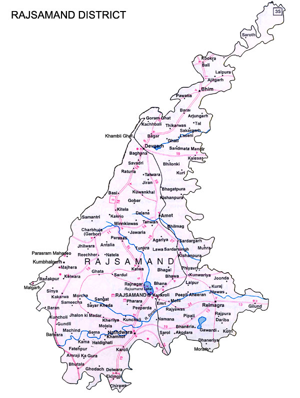
Rajasmand district is situated at the southern tip of Rajasthan adjoining Udaipur, Bhilwara, Pali, Ajmer, and Chittor districts and is oval in shape with a very narrow strip streching towards the North. It is bound by Ajmer and Pali in the North, Udaipur in the South, Bhilwara and Chittorgarh in the East and by Pali and Sirohi districts in the West.
Distance from Major Cities
Jaipur-409 Kms
Delhi-670 Kms
Climate and Rainfall
The district has moderate climate without significant seasonal variations.
The mean temperature is 22 degrees celsius.
Average rainfall at the district head quarter is 49.5 cms.
Administrative Setup
Administratively the district is divided into three sub-divisions, 7 tehsils and 7 blocks.
Human Resources
Indicators of Human Resources
Units
No.
Population
persons
9,86,269
Density of population
persons per sq. km
256
Literacy
per cent
55.82
Working Population
per cent of population
34.27
Percentage distribution of work force
Units
No.
Cultivators
per cent
54.87
Agricultural labourers
per cent
11.85
Household industry manufacturing
-
-
processing, servicing and repairs
per cent
6.00
Other works
per cent
27.17
Major Crops and Their Production
Sr.
Production 2004-05
Tonnes
1
Maize
56,900
2
Wheat
9,350
3
Jowar
9,030
4
Sugarcane
7,960
5
Barley
2,050
6
Groundnuts
1,470
7
Bajra
430
8
Rice
100
Mineral Production
Sr.
Production 1999-00
Tonnes
1
Copper ore
8264
2
Lead conc
30380
3
Zinc conc
4824
4
Barytes
2
5
Stealite
25602
6
Dolomite
97478
7
Fetspar
960
8
Quartz
49
Infrastructure
Electricity
Rajsamand district is fed power through grid sub-station from neighbouring districts. The district receives power supply from Rajasthan Atomic Power Project and grid sub-stattions at Debari, Asind-Bhim and Deogarh. The number of villages in the district is 967 all of them are fully electrified.
Water
Banas, Ari, Gomati, Chndra and Bhoga are the rivers flowing through the district. The depth of water level ranges from 10 to 40 metres. Various water supply schemes are providing dringking water in the district.
Road Transport
The National Highway No.8, Delhi-Ahmedabad-Mumbai road passes through the district and connects Rajsamand to Delhi. As of March 2000, the total road length in the district was 1,758 km.
Rail Transport
There is one railway track in the district, having a total lenght of 104 km of metre guage. The track is Udaipur to Jodhpur.
Air Transport
The nearest airport is at Udaipur
Communication Facilities
Sr.
Facilities
No.
1
Post office
210
2
Telegraph office
33
3
Telephone exchange
49
4
Public call office
790
Banking
Offices, Deposits and Credit as on Sep 2005
Offices (No.)
Deposits (Rs.Lakh)
Credit (Rs.Lakh)
All Scheduled Commercial Banks
61
65500
21700
Public Sector Banks
29
49300
18900
SBI and its Associates
20
34100
13300
Nationalised Banks
9
15200
5600
Foreign Banks
-
-
-
Regional Rural Banks
20
6300
2000
Other Scheduled Commercial Banks
12
9900
800
Educational Facilities/Institutions
Sr.
Facilities/Institutions
No.
1
College (General Education)
4
2
Prpfessional college
2
3
Secondary and higher secondary school
117
4
Middle school
313
5
Primary school
1248
6
Professional and special school
3
7
Other institution
62
Industrial Scenario
No. of large and medium scale running units: 7
No. of small scale units: 12,475
No. of industrial areas: 2
Export items Major export items are metallic decorative pieces, dyeing and printing items, fancy articles, marble decorative articles, marble slabs, pichwai paintings, silver miniature painting, stone chips and tarakota meenakari.
Main industries Major industries in the district are General Engineering Workshop, Handlooms, marble Slabs and Tiles, marble Chips and Powders, Marble Cutting, Miniature Silver Painting, oil Mills, Pichwal Painting, Silver Meenakari Items and Tyres and Tubes.